Try a walk in the Pentland Hills with our free sample route

Fancy a walk in the Pentland Hills? This sample route below is taken from the guidebook to Walking in the Pentland Hills by Susan Falconer.

Walking in the Pentland Hills
30 walks in Edinburgh's local hills
£12.95
Guidebook featuring 30 circular walks on Scotland's Pentland Hills, easily accessible from Edinburgh and home to peaks such as Scald Law and Carnethy Hill. Ranging from 2 to 17 miles, the routes are suitable for all abilities. Written by a local Countryside Ranger, the routes offer interesting and varied walking through diverse landscapes.
More informationWalk 1 - A Capital View.
From Walking in the Pentland Hills by Susan Falconer.
| Start/Finish | Hillend car park (NT249669) |
| Distance | 5.5km |
| Total Ascent | 390m |
| Time | 2hr |
| Maps | Ordnance Survey Landranger 66 or Ordnance Survey Explorer 344 |
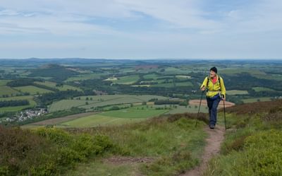
A short, and in places steep, walk rewarded with magnificent views across the city and surrounding hill ranges.
An excellent walk on a crisp winter’s day when time and light are short.
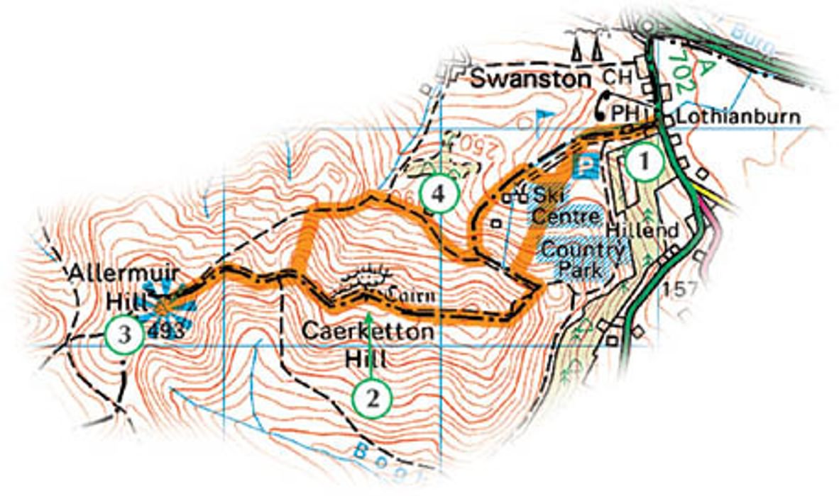
1
Begin at the Hillend car park next to the bus terminus at the entrance to the Midlothian Snowsports Centre. There is a waymarker post here – follow the sign indicating Capital View Walk.
Make your way uphill on a broad path over grassy slopes, then through sparsely wooded areas with bracken, gorse and trees, for about 600m. Follow the Capital View waymarkers and finger posts from this point.
Keep walking uphill on a path through Hillend Country Park to reach an open grassy knoll at NT245672, near the ski runs. From here you can admire the views over the city and beyond.
On the top of the knoll are the faint remains of a fort, possibly Iron Age. All that is visible of its rampart is a low mound and a stretch of ditch and bank, but with imagination the structures that would have been here 2000 years ago can be visualised.
Descend the knoll on a path to the west, and at another signpost indicating Caerketton, go through the metal gate and follow the path as it zigzags up the bulk of Caerketton Hill. Climb up onto the ridge, ascending 100m in 500m.
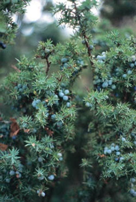
The shrubs in the wooden enclosures to your right on the way up Caerketton Hill are junipers, one of three conifers native to Scotland. Juniper is scarce in the Pentlands and bushes are scattered (they may once have been plentiful, but there is some dispute over this – see Malcolm Cant's Villages of Edinburgh: An Illustrated Guide Vol. II). To help re-establish juniper in the hills, the Pentland Hills Regional Park with Defence Estates, Forest Research and TCV (Scotland) are undertaking a programme of growing-on cuttings and berries to plant in other suitable places. Berries, which do not form on the juniper bushes until the bushes are eight years old, are used to flavour gin, as well as making a peppery seasoning for venison or duck.
2
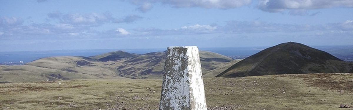
There is a tumbled-down cairn on Caerketton Hill, possibly of Bronze Age origin (see also Walk 27). Enjoy the views over Edinburgh and beyond, perhaps agreeing with Lord Cockburn that this is one of the three finest viewpoints in Scotland (along with Ben Lomond by Loch Lomond and Dumyat in the Ochil Hills, north of Stirling).
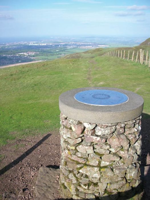
Continue on a path along the ridge until you start to descend rocky slopes to a bealach (pass) between Caerketton and Byerside Hill, at NT231664. (A stile and path leading downhill to your left drop down to Boghall Glen, which you could use to link with Walk 27, and return to Hillend via Boghall Plantation.) Continue over Byerside Hill on a muddy path, and then up the grassy slope of Allermuir Hill to its viewpoint indicator and trig pillar at 493m.
The original indicator on Allermuir Hill was presented to the National Trust for Scotland in 1963 by Arthur Russell, the Trust’s law officer. The indicator also includes a reminder that the northern slopes of the Pentlands are protected by a conservation agreement between the landowner, Major Henry Trotter, and the National Trust for Scotland.
3
Descend Allermuir Hill by the same route over Byerside Hill and return to the bealach below Caerketton. Instead of climbing back over Caerketton (although this is an option), take a grassy path that goes north, leading downhill. This path divides lower down, and you should follow it as it cuts to the right across the lower slopes of Caerketton, overlooking the T Wood towards Hillend, and passingMuilieputchie (NT236666 – not shown on the OS 1:50,000 map).
The unusual name Muilieputchie is found on the OS 6in to 1 mile map of 1852, and according to S Harris’sThe Place Names of Edinburgh, Their Origins and History (see bibliography), may be British moel or Gaelicmaoile, meaning ‘hill brow’, and Gaelic poiteag, a ‘pit’ or ‘well’, or British puth. However this is disputed, and the name may have a Scots root, moolie meaning ‘mouldy’, and pooch meaning ‘pocket’, hence ‘a damp hollow’.
Viewed from Edinburgh the T Wood resembles a letter T, but in fact it is in the shape of a Maltese cross. It was planted in 1766 by Henry Trotter, to commemorate a member of the Trotter family of Mortonhall who had fallen in battle. The wood is mainly of beech trees, which cast a lot of shade, so there is very little understorey of other plants.
4
The path continues alongside the fence overlooking the former Lothianburn Golf Course. Keep on this path until you reach a gate and a path where sheep and horses now graze the fairways and greens at the side of the plantation of conifers on the west side of the ski runs. Take this path steeply downhill and emerge at the ski centre upper car park. Head downhill, picking up a path that runs parallel to the road and return to the start.
To read more articles like this get our newsletter
Sign up for 20% off your next purchase and to be the first to hear about exclusive competitions, special offers, and news from Cicerone.