An Introduction to The Snowdonia (Eryri) Way
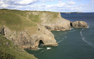
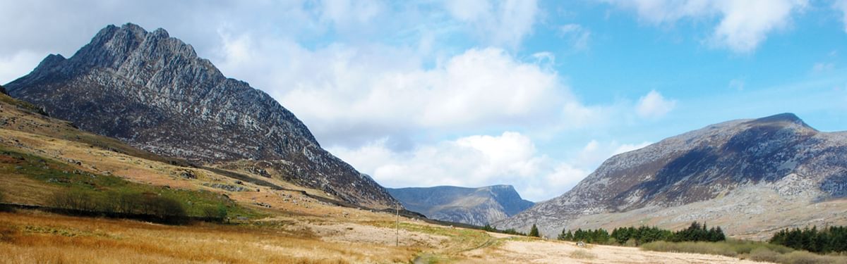
Eryri (Snowdonia), an area encompassing the mountains of North Wales, is a wild expanse of peaks, valleys, woodland, and miles of coastline and estuaries. In a short distance you can walk from the sandy beaches of Tremadoc Bay, through the forested river gorge of Aberglaslyn Pass, up to the flanks of Yr Wyddfa (Snowdon) itself – the highest mountain in the land.
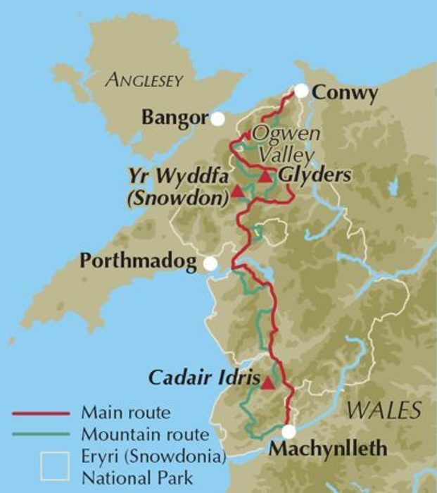
The Snowdonia Way is a long-distance walking trail that takes you the full length of the National Park, from Machynlleth in the south to Conwy in the north, between the two great rivers that mark the southern and eastern edges of the region, the Dyfi and the Conwy. For 97 miles (156km), walked in six days, you’ll see the many sides of Eryri, and explore its nature and history with the option of summiting some peaks. There are good transport links in all the towns and villages passed through, meaning you can attempt the whole route in one go, or split it up as you see fit
The main route
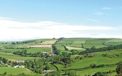
The main route is primarily low level, taking valley tracks and hillside paths, encountering old rights of way through forested slopes, and even using Roman roads. There are some steep ascents and descents to encounter, but the route avoids the peaks, meaning it can be walked by those wishing for a journey through the landscape, gazing up at the mountains but enjoying the feeling of being in the valleys.
The mountain route
For those who want to climb some mountains on the way, a high-level route has also been devised. This route intersects with the standard route regularly, so you can switch between them when you feel like it or when the weather dictates, or you can walk the whole high-level route from beginning to end. This route is 122 miles (196km) in total and is done in nine stages, also between Machynlleth and Conwy.
Although many of the overnight stops are the same, there are a few instances where they do not quite overlap. The only night, however, where the high-level route spends the night far from any intersection with the low-level route, is after Stage 1A in Abergynolwyn. Other than that, it is relatively easy to swap between them when you see fit.
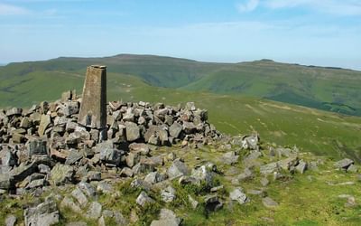
This route gives you a spectacular journey over Eryri’s mountains, climbing the most famous peaks such as Yr Wyddfa (Snowdon), Cadair Idris, Cnicht and the Glyders, and also taking you to some of the peaks less visited, which you may have all to yourself.
Why should you walk the Snowdonia Way?
Eryri (Snowdonia) has that perfect mix of wilderness and accessibility, whilst containing everything from high rocky peaks, to forests and sandy estuaries. As a walker you really feel that you are out in the remotest corner of the world, before abruptly finding yourself in a village with brilliant pubs, cafés and accommodation.
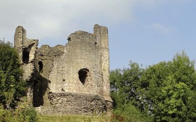
On every day of the walk there is a different feature of huge historical, geological or cultural interest. It's astounding how much there is, and how regularly you come across sites in the landscape that on their own are worth travelling across the country to see. Neolithic remains, Edward I's castles and the great spoil tips of abandoned slate mines are just a few examples.

The Snowdonia Way
A walking route through Eryri from Machynlleth to Conwy
£16.95
Guidebook to walking the Snowdonia Way in Wales, a long-distance route through Eryri (Snowdonia) National Park from Machynlleth to Conwy. The low-level route of 97 miles (6 to 8 stages) includes the Pass of Aberglaslyn, the Ogwen Valley and Aber Falls. The mountain route is 122 miles in 9 stages, including Cadair Idris, Yr Wyddfa (Snowdon) and the Glyders.
More informationWhen to walk the Snowdonia Way
Being on the west coast of Britain, Eryri (Snowdonia) has a mild climate, where rain can fall at all times of year. There is snow on the mountains frequently during the winter and sometimes down to the passes and valleys. Despite the stereotype that the UK’s mountains are cold and wet, the spring, summer and autumn can be regularly warm and cloud-free. The low route of the Snowdonia Way is possible to attempt all year round, although during very cold periods there can be snow on the passes. The high route stages are only possible in winter conditions with a full knowledge of winter mountaineering and appropriate equipment, including crampons and ice axe.
Mountain weather can change rapidly; low cloud, strong winds and heavy rain are possible at all times of year, but then again the risk of sunburn is more common than you might think.
How hard is the Snowdonia Way
The main route, although low-level, varies between good tracks and indistinct paths, with everything in between. The trails can be uneven underfoot and the stages are full days of walking, typically with long stretches between shelter. Anyone of average fitness and stamina can complete the route – although the stronger your legs, the more you’ll enjoy the uphills. To do this route, you should be comfortable walking for up to 8 hours per day in undulating terrain, carrying a pack.
The mountain route is, by definition, over the mountains, and is therefore much more challenging. Some of the stages are long and remote – especially Stage 6B – and you should have good fitness and stamina to attempt any of them. There are often sections of risk, close to steep drops and crags, the paths are frequently obscure or non-existent, so good navigation is paramount. The ability to keep comfortable in changing weather, sometimes hours from shelter, is vital. To do this route, you should be comfortable walking for up to 10 hours per day over high peaks and moorland, with a suitable pack.
Stage Summaries
The Snowdonia Way - Main Route Summary
| Stage | Distance | Ascent | Approx time |
|---|---|---|---|
| 1 Machynlleth to Dolgellau | 15½ miles (24.7km) | 2460ft (750m) | 7–8hr |
| 2 Dolgellau to Trawsfynydd | 14 miles (22.6km) | 2590ft (790m) | 7hr |
| 3 Trawsfynydd to Beddgelert | 18½ miles (29.5km) | 3050ft (930m) | 8–9hr |
| 4 Beddgelert to Dolwyddelan | 12¾ miles (20.6km) | 2625ft (800m) | 6–7hr |
| 5 Dolwyddelan to Bethesda | 15½ miles (25.1km) | 2165ft (660m) | 7–8hr |
| 6 Bethesda to Conwy | 21 miles (33.6km) | 4855ft (1480m) | 10–11hr |
| Total | 97¼ miles (156.1km) | 17,745ft (5410m) | 45–50hr |
The Snowdonia Way - Mountain Route Summary
| Stage | Distance | Ascent | Approx time |
|---|---|---|---|
| 1A Machynlleth to Abergynolwyn | 12 miles (19.5km) | 3575ft (1090m) | 6–7hr |
| 1B Abergynolwyn to Dolgellau | 14¾ miles (23.6km) | 4890ft (1490m) | 8hr |
| 2A Dolgellau to Trawsfynydd | 16½ miles (26.6km) | 4560ft (1390m) | 9hr |
| 3A Trawsfynydd to Penrhyndeudraeth | 11¾ miles (18.9km) | 2855ft (870m) | 6–7hr |
| 3B Penrhyndeudraeth to Beddgelert | 15¾ miles (25.2km) | 4495ft (1370m) | 7–8hr |
| 4A Beddgelert to Pen-y-Pass | 11¼ miles (17.9km) | 4855ft (1480m) | 6–7hr |
| 4B Pen-y-Pass to Capel Curig | 9½ miles (15.5km) | 4165ft (1270m) | 5–6hr |
| 5A Capel Curig to Bethesda | 12¾ miles (20.4km) | 5380ft (1640m) | 7–8hr |
| 6A Bethesda to Conwy | 18 miles (28.7km) | 5215ft (1590m) | 9–10hr |
| Total | 122¼ miles (196.3km) | 39990ft (12,190m) | 63–70hr |
To read more articles like this get our newsletter
Sign up for 20% off your next purchase and to be the first to hear about exclusive competitions, special offers, and news from Cicerone.